Sunday May 28, 2017
[update May 25: after Wednesday’s heavy rain, there are some newly fallen trees and the marshes are even wetter – bring spare socks and shoes and perhaps some old newspapers to stuff into your wet shoes. Mosquitoes in the woods, but not many in the open areas;
May 23: course lengths added]
Out-of-town event at the Waskehegan Staging Area of
Cooking Lake-Blackfoot Provincial Recreation Area
52365 RR210, Sherwood Park (putting that into Google maps may not work)
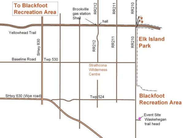
Directions and location map below.
Event goes RAIN or SHINE. Bring extra shoes and socks to change into afterwards. Weather forecast
REGISTRATION/STARTS from 1:30pm until 3pm. All those registering on-the-day are required to fill out and sign a lilac waiver. Beginner instruction available during this time.
FINISH no later than 5pm.
Terrain: large undulating grazing fields surrounded by fences. with some areas of woods and wet areas.
Map scale 1:7,500 contour interval 2.5m
Courses:
Distances are as-the-crow-flies and do NOT include the 1.7km walk to the start along a gravel road
1 – Beginner – controls on paths or other linear features such as fences, edges of trees, edges of marshes, a beaver dam!!! or following flagging. 2.5km 18 controls.
2 – Novice – controls close to linear features (such as paths/fences) 3.0km 16 controls.
3 – Intermediate, with controls across country with ‘catching features’ behind the controls. 4.2km 11 controls.
4 – technically advanced. 4.0km 9 controls.
6 – technically advanced (longer). 5.4km 12 controls
The easier courses will be in the grazing pastures, surrounded by a fence.
Fees*:
$15 per non annual-member individual/couple/family. Fee includes a map, rental of SPORTident timing card, rental of compass and whistle if you don’t have your own and beginner instruction if needed..
$10 per annual member (EOOC/FWOC/OC) individual/couple/family. Fee includes a map, rental of SPORTident timing card, rental of compass and whistle if you don’t have your own. Driver’s licence required for rentals.
$5 per additional map for couples/families going out together.
$5 per Junior annual member going out solo.
Driver’s license required as deposit for rentals.
NB: no addition charge to go out on a second course, if there is still time.
* no fees for those pre-registered for the skills camp (full weekend or Sunday only)
Facilities: Waskehegan Staging Area has a shelter and better-than-average outhouses.
Organizers:
Course Planner – Geraint Edmunds, Orienteering Canada certified Level 300 Official
More information:
Check back to this web page for updates or email Marilyn <eooc<AT>shaw<DOT>ca>
DIRECTIONS: 20km east of Sherwood Park
Easiest route is east along the Yellowhead Hwy to the Elk Island National Park flag pole, then south down RR 210 for about 7km. Turn left into the Cooking Lake / Blackfoot Provincial Recreation Area, Waskehegan Staging Area parking lot. Registration will probably be in the shelter on the east side of the parking lot.
Or east along Baseline Road (becomes Twp 530) to the T junction with RR210. Turn right and go south for about 4km. Turn into the Cooking Lake / Blackfoot Provincial Recreation Area, Waskehegan Staging Area parking lot. Registration will probably be in the shelter on the east side of the parking lot.
Or east along Wye Road. Just after the road bends to the southeast, turn left onto Twp 524, crossing the railroad tracks. Continue east to the T junction with RR210. Turn right and drive south for just over 1km. Turn into the Cooking Lake / Blackfoot Provincial Recreation Area, Waskehegan Staging Area parking lot. Registration will probably be in the shelter on the east side of the parking lot.
 Brookville Hall has a distinctive steep-pitched roof.
Brookville gas station is no longer a Shell station.